 As I mentioned a couple of days ago, Kim Baldwin and I went on a somewhat short, somewhat whirlwind tour through St. Vincent and the Grenadines to give workshops on Kim's Grenadines MarSIS project. Kim created a map of the sea using GIS to gather all the data into a single location and I extracted her data and brought it into Google Earth. The details on how that was done, the steps and stuff, I'll but in my other blog.
Here is a reporting of our trip. Unless noted, the photographs are mine.
Also, you can see where we went by using Google Earth. I made this file with the locations (clicking it launches Google Earth).
Lat: 13° 4'41.65"N; Long: 59°29'19.51"W - We left Grantley Adams International Airport in Barbados on November 8 on Liat Airlines with only a minor delay. Our flight got into St. Vincent at about 7 pm.
Lat: 13° 9'15.24"N; Long: 61°13'27.55"W - That evening we stayed at the Heron Hotel next to Heritage Square.
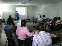 Lat: 13° 9'16.10"N; Long: 61°13'35.68"W - The next morning, November 9, we got up early and wheeled our suitcases and gear the two blocks to the Fisheries Division in Kingstown, St. Vincent. The workshop was to start at 9 am but we got there early because we had to set up a wireless system, get the projector going and make sure the laptops were loaded with the presentation materials. We also had to get the room ready for the participants and pass out folders with the agenda. We carried with us in those suitcases abut six laptops between us, plus all the electronic equipment we thought we might need. We used it all.
The audience consisted of people already familiar with the MarSIS project and this workshop and the others to follow was a way for Kim to update the stakeholders on her progress. Kim gave her talk on what her project was about and what GIS is, but she also ran through many demonstrations on doing GIS analysis with the MarSIS geodata. Using ArcGIS, Kim did select by location, select by attributes, queries and summary tables, among others. This got the participants interested in her data, which is really their data, as they helped collect it and helped to identify what was needed for such a geodatabase.
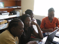
 Once Kim finished her presentation, I ran through a demonstration on how to use Google Earth. I showed the participants how to add their own data as placemarks, lines, polygons and scanned maps. After breaking for a yummy lunch of West Indian food we all came back and they got to 'play' with the MarSIS data using Google Earth. The screen capture to the right is all I can show for now, until I integrate all the great comments from the attendees.
What you do see in the screen capture is a map of the shallow water habitat near the island of Mayreau, plus Turtle Nesting Beaches and beaches where you find Whelks. This just scratches the surface for what's available.
The workshop ended at 3 pm or so with folks filling out surveys, having a Q & A session to get some more user feedback and packing up to make a flight. The response to this workshop was overwhelmingly positive.
We got a ride back to the St. Vincent airport and checked in to take a puddle jumper flight on Grenadines Airlines to Union Island. We sat down and waited for boarding. The appointed time came and went. The sun went down and we kept on waiting. Turns out our flight was canceled (because the Union Island airport does not have runway lights). We had another workshop to give at 9 in the morning so this did not please us. However, it peeved the Union Islanders even more. They raised hell and we ended up getting set up in a place for the night, plus some more West Indies food for dinner.
Lat: 13° 8'39.23"N; Long: 61°13'15.38"W - We got driven to the apartment by the man who owns the apartment. On the way there, he stopped in at a what looked to be closed restaurant to ask for some food to be cooked up and sent to the apartment. When we arrived to the apartment, the room was clean and nice, but it was dark outside so we could not see the view, though we knew there was one. This was the view at sunrise.

When we were at the St. Vincent airport the night before, Kim managed to get booked on the first flight out to Union in the morning. I was going to go on standby but it was pretty critical that I made that flight too.
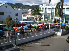
 Lat: 12°35'44.29"N; Long: 61°25'5.56"W - OK, so tragedy averted, both Kim and I got on the first flight out of St. Vincent and we got the second workshop by 9:30am, only a little late. Fortunately, so was most everyone else. Might have something to do with Caribbean time. The second workshop was held on Union Island at the office of Sustainable Grenadines, above Mitchel's Hardware on the main road in Clifton. We repeated the everything we said and did in the first workshop, and we both think our presentation improved. Actually, the workshop had a different flavor than our previous workshop, not better or worse, just different questions and interests. I can't wait to see the survey results.
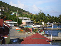 We stayed at the Clifton Hotel, a funky place right in town and on the water, right down the street from the workshop location. Clifton and Union Island reminded me of a place Jimmy Buffet would sing about. It was pretty cute.
Kim seemed to know everyone in town. Not surprising. Union Island is part of her field area. I think she must know all the islands and the locals living in the Grenadines in this way. That evening we ate at Ciao Pizza and had rum and Hairoun bitter lemon at the rum shop next door.
Lat: 12°38'0.54"N; Long: 61°21'17.45"W - On Wednesday,
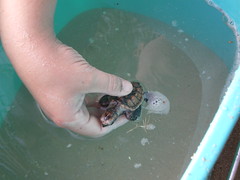
 November 11, we had a free day, so to speak. In the morning, Kim needed to attend to some speech work but in the afternoon, for two hours, she took me out for some amazing snorkeling at the Tobago Cays Marine Park. We were let out near Horseshoe Reef and snorkeled/swam back to Baradal cay to be picked up by a water taxi. We saw sea turtles galore, parrot fish, trunk fish and loads of different types of coral. It was incredible. There are no permanent structures in the Tobago Cays so you get there by boat and then leave when you're done for the day. There were a few catamarans and sailboats out there, but in high season, there are sure to be loads more. It was the most beautiful blue water I have seen...the kind of 'Caribbean blue' in post cards. I did not have my camera with me so take a look at jaja13's shot of the Tobago Cays found on Panoramio.
Whew! That two hours alone was worth all of the efforts getting around with heavy luggage, and we still had another workshop left to do. If you want the fly-through version, check out the Google Earth tour to see how we got around.
Lat: 12°29'0.77"N; Long: 61°27'32.46"W - We took a water taxi to get to Carriacou, went to Immigration and got our passports stamped their, and then took a passenger ferry over to Grenada. I took video on this part of the journey, no photos.
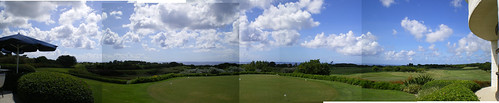
 Lat: 12° 2'30.49"N; Long: 61°44'55.01"W - We got into Grenada by ferry and took a taxi to our hotel, The Lazy Lagoon. This is the view from the parking lot, it's right on the bay or lagoon. We stayed here Nov 11 and 12.
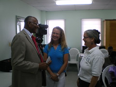 Thursday morning we got to the third workshop, at the Fisheries Department (couldn't find the lat/long). This workshop had media present, reporters and cameras. Why? Because the Honorable Dennis Lett, Minister of Agriculture, Forestry, Fisheries, Public Utilities and Energy gave the opening address for this final workshop. The workshop opened with Justin Rennie, the Chief Fisheries Officer of the Grenada Fisheries Division giving a speech. Kim also gave her overview talk. In the photo to the left is Mr. Lett, Kim Baldwin and me.
The workshop went much like the other two, great feedback, happy participants. We hope to write up some sort of paper on the outcomes of the workshop and the use of Google Earth, a web 2.0 technology, and the ability to deliver geospatial data to anyone with access to a computer.
Here is where we went during the short trip. Clicking on the link will launch Google Earth.