Pages

7.26.2010

"If Ya Bajan and Ya Love Ya Teacher, Raise Ya Hands!": Junior Kadooment

For the past few months the Barbadian radio stations have been playing an endless rotation of soca music (hear it in the videos below) all in the run-up to Crop Over. Crop Over happens August 2 this year and is so named for the end of the sugar cane season.

Saturday was Junior "Kiddie" Kadooment and was a miniature version of what we might expect on August 2, only without all the alcohol and bacchanal. This was such a sweet affair that I'm really glad I went and took the kids and I'm glad I got lots of video of the little paraders.

We met up at the beginning of the parade route and watched the marchers make their way to the National Stadium where the various "bands" of kids parade across the stage in front of the judges. The title of this post is a reference to something the M.C. said from the stage. There's a lot of emphasis on and value placed in education and teachers are very well-regarded in Barbados. Yet another thing we should adopt in the U.S.!

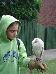
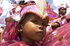
The photo of the little reveler is by Risee on Flickr and not by me. I had yet another camera failure and did not get still photos of the kiddie kadooment.

But I did get plenty plenty video of the young paraders. Check it out, but be cautious, it's a little loud:


The event that followed the parade was a Junior Calypsonian competition that, unfortunately, we could not stay for. One of the opening acts for the the show was a young soca group (the Hypa Kidz) that has a song out this Crop Over season called "Happy Feet." You can hear "Happy Feet" in the first video with the little parade marchers. Here is Hypa Kidz' performance:

7.22.2010

Hawksbill Turtle Tracks


School is out for the summer and now we find ourselves heading down to the beach a little earlier in the day. This video was taken at about 7 am yesterday. I went out for my run in the morning and saw a lot of Hawksbill turtle tracks and nests but these two were right in our back yard. I had to bring the kids down to see them.

I love living here. We're going to miss it.

7.08.2010

Return Home, Reflections on Trip

Latitude: 51°10'11.98"N; Longitude: 0°10'21.42"W

We had a L O N G drive to the hotel (Corner House Hotel in Horley) which is very close to Gatwick Airport. We kept is lively with The Mists of Avalon. But it was still a little too long for all of our tastes. Though the scenery has been remarkable for most of the trip, the highway (I believe it was the A1(M)) south towards London is less than lovely. Gatwick Airport is still south of London and not really in London. We never saw London on this trip. It's for another time.

Latitude: 51° 9'1.57"N; Longitude: 0°10'35.95"W

We dropped off our rental car (or would that be a 'hire car'?) at Hertz and then went into Gatwick to wait for the flight. What a wonderful trip we all had. There were so many cute towns and sweet places to see. The countryside is so pastoral. Parts of it, with the rolling green hills and grazing bovine, looking strikingly like...New England. Imagine! The history of the UK is incredible, from the Romans to the Vikings and the Normans. Catholicism, Christianity, paganism. The castles and cathedrals, royalty and the commoners, or I mean everybody else. Just driving around and getting out at places along the way reveal the long history of being conquered and a history of conquering and creating the British Empire. It's all so fascinating to someone from the U.S., where our history of colonialism started in the 1600's, we have no real royals (except for maybe our super wealthy) and we are a much larger, geographically speaking.

The trip was a great way to celebrate the end of the school term for the kids and the wrapping up of the Fulbright and sabbatical work for us. If I could shell out some advice...got your kids a passport and take them places, early and often.

The photo at top is from Alnmouth, England, the second photo is from Cambridge, England, and the last photo was taken in Edinburgh, Scotland. These photos and more from the trip are located on my Flickr page.

7.06.2010

Holy Island (Lindisfarne) England

Latitude: 55°40'8.49"N, Longitude: 1°47'5.01"W

We made the pilgrimage to the Holy Isle in northern England. Lindisfarne is another name for the Holy Island. Along the way on this trip we've been listening to The Mist of Avalon on an MP3 player piped through the radio, this is to get us in the spirit of Olde England in the times of King Arthur and the priestesses and the druids. Marion Zimmer Bradley invokes the Holy Isle of the Christian priests and the Lady of the Lake, shrouded in mist, next the Holy Isle. I am still not sure if the Holy Island is thee Holy Isle of the The Mists, but I like to think there is some pagan blood and sweat in the ground here. Now, it seems, the property is for sale.

To get out to the island, one must wait for the tide to recede, to leave, you must be mindful of the rising tide. The castle shown at the right is an Elizabethan fort that protected the Holy Island harbor. Building on the castle began in 1570 and was used as a fort for over 300 years. It has been privately owned for about 100 years.

Latitude: 55°40'9.44"N, Longitude: 1°48'3.33"W

The village is the site of the lovely Lindisfarne Prior, one of the most important centers of British Christianity. The Priory was founded in AD 635 and is the site of St. Cuthbert's remains. The ruins are beautiful, with large stone arches of weathered red sandstone and preserved building spaces showing the monks housing quarters for when the site used to be a monastery. There is still an active church right next to the Priory because there are about 200 people who live in the Holy Island.

We got to see an interesting raptor display on Holy Island. Given by raptor rescue people, apparently owls have been purchased in abundance following all the Harry Potter joy. Well, people, you cannot keep an owl in a little cage, like Harry does, and expect it to be very pleased. The kids liked getting to hold an owl and a hawk and now hope to volunteer at the local Raptor Center back home when we get back to the U.S.

For dinner we ate in a pub. I had Shepard's Pie and a pint. One odd thing, though, we couldn't find a place to eat at 5:30 pm and had to wait until dinner was served locally at 6 pm. This is a phenomenon we encountered at that time in most places around the UK. It wasn't a big huge deal but we did not want to get caught trying to get back to Alnmouth at high tide. No worries. We made it.

These photos and more from the trip are located on my Flickr page.

7.05.2010

Seahouses and the Farne Islands, England

Latitude: 55°34'58.30"N, Longitude: 1°39'9.06"W

We drove from Alnmouth north to a town called Seahouses. From here we caught a boat (the Serenity II, if you go, look for this tour operator) out to the Farne Islands to see the puffins. That was the plan. We ended up seeing so much more. Yes, we saw puffins, Eiders, shags, terns, razorbills, guillemots, and gulls on the shores. We also saw sea lions and loads of jelly fish. We got out and walked around for an hour on a National Trust site on Inner Farne and saw the nesting birds very up close. Sometimes up too close as the parent birds, protective of their young or their eggs would swoop very near our heads, shewing us onward and away. It was fun though. Gulls make their nests right on the edge of a cliff. Puffins make a burrow for their eggs and hatchlings.

We also saw St. Cuthbert's Chapel on Inner Farne. Cuthbert figures prominently in the Christian history of northern England so it was interesting to see this sweet little chapel on this rugged, bird-filled rock island.

These photos and more from the trip are located on my Flickr page.


Added July 22, 2010. My daughter made a video of her birding experience on the Inner Farne. Here's her YouTube channel.

7.04.2010

Alnmouth and Alnwick in England

Latitude: 55°23'25.85"N, Longitude: 1°36'51.26"W

We are staying in Alnmouth very close to Alnwick, England. This is another self-catering place (Midwood Lodge) and it seems brand new. Our luck! The owner left a bottle of wine, some lemon cake and cookies to welcome us.

Latitude: 55°24'55.50"N, Longitude: 1°42'21.12"W

We went to Alnwick Castle this morning. This castle was on our plans at the outset of the trip. It was billed to us as the "Harry Potter" castle. I imagined the castle of the large spires and rustic setting next to a lake. This is not that one. I think that castle is in Romania somewhere. This castle was okay. The first two Harry Potter films had some filming done on the grounds of the castle. I think that scene where Harry learns how to ride the broom is in the bailey. But still, I don’t have many castles in my American life and any castle provides some intrigue. This castle has been in the Percy family since the 1300's. Yes, they are royalty and no, no other people but the Percy's will ever be able to own or live in this castle and this concept is difficult for an American to take on. Happy Fourth of July, by the way. This is a unique castle in that it is or was both a castle (an armament) and a palace (the place where the duke and duchess lived). The current residents live there in the "off season" after the tourists are no longer allowed to see the place. When they come to live in the castle, they actually use the space; their pictures are all over the place. It was kind of creepy. And when they come to Alnwick, they hunt ground birds. No, that is not a life I am familiar with.

Alnwick Gardens, close to the Castle, were beautiful. The kids really liked the maze made of bamboo. I find those scary and claustrophobia-inducing. The perennial garden and rose garden were stunning. Be sure to go through the poisonous plants walk and see all the medicinal plants that are used for all sorts of cures and that the pharmaceutical industry wants to now label as "dangerous." There was even cannabis in the garden.

These photos and more from the trip are located on my Flickr page.

7.03.2010

Siccar Point in Scotland

Latitude: 55°55'46.36"N, Longitude: 2°18'2.08"W

We left Edinburgh and drove east to find more connections to James Hutton. We made our way to Siccar Point in Scotland and found a couple of placards, one reading that Siccar Point is "arguably the most important geological site in the world." It was breathtaking. This is the location that Hutton came up with the idea of an angular unconformity (see the picture below)- that much time passed between two very different rock formations and that earth is older than 6,000 years. Much older. Getting down to see and walk on the outcrop was tricky but worth it.

By the way, if you want to view Siccar Point from the aerial view (using the location above), don't use Google Earth as the aerial photography for this coastal location is oddly obscured and out-of-date. Use Bing Maps.

We hit a couple more Hutton-significant locations along the way. But I really liked stopping and picking strawberries. We picked so many strawberries that we went a little crazy. But they tasted amazing.

These photos and more from the trip are located on my Flickr page.

7.02.2010

Beautiful Edinburgh, Scotland

Latitude: 55°56'59.46"N, Longitude: 3°11'39.66"W

Like all of our accommodations, we found this self-catering apartment (Capital View Apartment) on the internet and made the arrangements before we left. It was in a perfect location for seeing Edinburgh, right next to the Royal Mile.

Latitude: 55°56'56.17"N, Longitude: 3°11'40.75"W

We had breakfast (and then lunch because we liked is so much) at a renovated and re-purposed cathedral, now called the HUB. In addition to food, they have performances at the HUB and the Edinburgh Festival.

Latitude: 55°56'54.92"N, Longitude: 3°11'53.76"W

After breakfast, we walked up the hill to the Edinburgh Castle. This place was packed and was almost a little like Disneyland, but ended up being worth it. The cost to enter was $20 USD per adult. The views from this armament, located on a huge, tall piece of rock in the middle of Edinburgh, were well worth it. You can see the Firth of Forth, Arthur's Seat (has nothing to do with THAT Arthur) and another castle/abbey ruin on another hill. We were fortunate to have a beautiful and clear day.

Latitude: 55°56'47.07"N, Longitude: 3°10'27.08"W

Then we went on a James Hutton quest. James Hutton, a native of Edinburgh, was the father of the science of geology. We visited his birthplace, a memorial and a monument in his honor. We walked along the Salisbury Crag (we are the specks on the picture to the right climbing up the trail) near Arthur’s Seat and saw the contact between an igneous sill that intruded into a sedimentary rock formation. This is a walk young Hutton must have made many times as he pondered the age of the earth and how it formed.

Latitude: 55° 56′ 48″ N, Longitude: 3° 11′ 32″ W

We also visited James Hutton’s grave at Greyfriar’s Cemetery. His headstone was locked away in a part of the cemetery not open to all but that didn’t mean it was in some cared for condition. No, it was difficult to even see his headstone without the help of the person working there. One added bonus to going to this cemetery has a Harry Potter aspect to it. Not far away from the cemetery was the café in which J.K. Rowling wrote the first Harry Potter book. The café is called Elephant House. We had to eat there, as we are all major Potter fans. But this cemetery must have been the location of some reflection and inspiration for Ms Rowling in addition to her long-milked coffee at the café. We saw the headstones labeled with the last names Moodie, McGonagall, Black (this one was Josephus), and Thomas Riddell. From inside Elephant House, Ms Rowling would have looked out the window to see Greyfriar’s.


Edinburgh is a beautiful and terrific city. It reminds me of San Francisco with its hills, youthfulness and loads of things to do. I was wish we had a little longer to explore.

These photos and more from the trip are located on my Flickr page.

7.01.2010

Hadrian's Wall

Latitude: 55° 1'33.72"N, Longitude: 2° 8'23.24"W

We drove north towards Edinburgh today. Along the way we stopped to see Hadrian’s Wall at Chester’s Roman Fort near Walwick, England. Hadrian’s Wall was built during Roman rule – about 22 AD to 306 AD – and much like the Great Wall of China, this wall was meant to keep out northern marauders from infiltrating Roman Britain. Much of Hadrian’s Wall has crumbled away or was re-purposed for newer walls and stone structures. Add to that the fact that there’s a large build up of soil, Hadrian’s Wall would require a true excavation to unearth all the finials, tombstones, alters, and other clay , stone and metal artifacts. There is a museum at Chester’s Roman Fort that has many of these types of findings. In addition, there is a well documented excavation of a Roman fort. These forts were built about every mile along the Wall and within the fort housed a troop of soldiers, horses, cooks and commanders. Hadrian’s Wall is over 70 miles long.

This was a great stop along the trip.

Zoom to the location (given above) in Google Earth. The aerial view is striking. Turn on the Panoramio photos for the on-the-ground view.

These photos and more from the trip are located on my Flickr page.